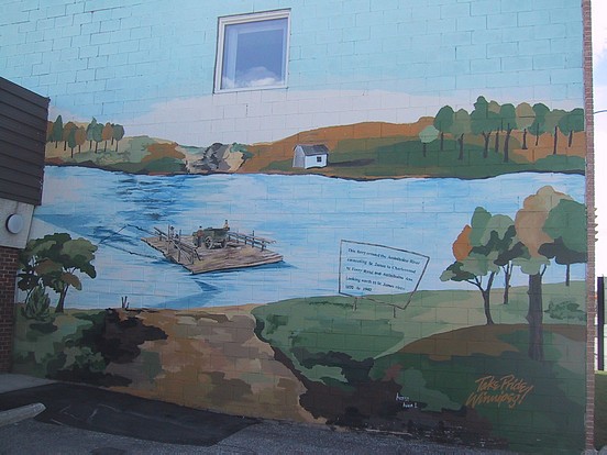
John Steel (St. James BIZ): "We found this scene with the help of Manitoba Archives.
This is Ferry Road and it crosses Portage Avenue and runs south to the Assiniboine
River. At one time a ferry actually operated across the Assiniboine River at end of Ferry
Road and connected St. James to Charleswood. If you look at history there were
hundreds of ferries across the province. The ferries were the only means of crossing the
rivers before bridges were built. We went to Manitoba Archives, came up with some
pictures of the actual ferry in its location and gave it to the artist, a Russian girl."
"The Ferry was water propelled. As the current flowed downward, the cable at the front would
orient the ferry at the right angle so that as the current rushed by, it would literally power
or slide the boat across the river on the cable under waterpower. At the other side coming
back, everything but the direction of the river flow was reversed. The cable at the front
combined with the water pressure would tilt the ferry at the appropriate angle to again be
propelled across the river by waterpower. And these ferries were great big rafts! You
could put a couple vehicles some people a horse and buggy, and goods on them and haul
them across the river! We wanted to capture this little bit of St. James history on the
Mural!"